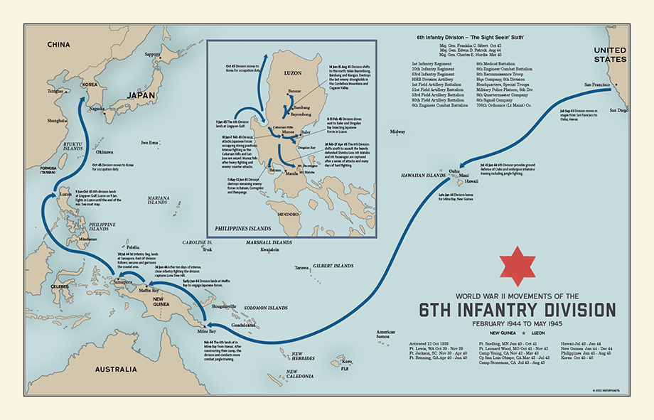
6th Infantry Division Campaign Map
Across New Guinea and Luzon, the “Sight Seein’ Sixth” fought through jungle, ridges, coastal landings, and mountain defenses.
Size:
24 x 18
6th Infantry Division Campaign Map
If you have any questions, you are always welcome to contact us. We'll get back to you as soon as possible, within 24 hours on weekdays.
-
Shipping Information
Use this text to answer questions in as much detail as possible for your customers.
-
Customer Support
Use this text to answer questions in as much detail as possible for your customers.
-
FAQ’s
Use this text to answer questions in as much detail as possible for your customers.
-
Contact Us
Use this text to answer questions in as much detail as possible for your customers.
6th Infantry Division Campaign Map
The 6th Infantry Division’s World War II route ran through the Pacific, where distance, jungle terrain, and fortified Japanese positions shaped every stage of the campaign. Known as the “Sight Seein’ Sixth,” the division trained in Hawaii and New Guinea before entering combat in Dutch New Guinea in June 1944.
Its first major test came at Lone Tree Hill near Maffin Bay. There, the division fought against cave and bunker positions cut into steep ground, with repeated counterattacks slowing the advance. After securing the Maffin Bay area, the division made an assault landing at Sansapor on the Vogelkop Peninsula, helping extend Allied control along New Guinea’s northern coast.
In January 1945, the 6th Infantry landed at Lingayen Gulf on Luzon and moved into the campaign to retake the Philippines. It fought through the Cabanatuan and Cabaruan Hills, seized key towns and road centers, and drove east toward Dingalan and Baler Bays, helping divide Japanese forces on the island. Later, the division shifted to the Shimbu Line northeast of Manila, where rugged mountain defenses forced a slow fight from ridge to ridge. The map shows a Pacific campaign defined by coastal movement, inland pursuit, and difficult fighting through some of Luzon’s hardest terrain.
PAPER & PRINTING
Printed on archival-grade, acid-free matte fine-art paper with a natural surface for crisp detail, accurate color, and lasting display quality.